
Hikes in Japan: Mt. Myojingatake Trail (明神ヶ岳)
Summary
The hike up Mt. Myojingatake is a great hike for anyone with a moderate level of fitness to take while visiting the Hakone area. From the middle of Hakone this hike is just over 5 miles round trip, on a mostly well maintained trail, but it has approximately 2,200 feet of elevation gain which is why I recommend having a moderate level of fitness before attempting. Those that do attempt this hike are rewarded with some amazing views of the Hakone area and Mt. Fuji. This is a highly recommended hike.
Have you hike Mt. Myojingatake before? If so click a star below to let other readers know what you thought of this trail.
User Review
( votes)BASIC INFORMATION
- Name: Mt. Myojingatake Trail (明神ヶ岳)
- Where: Hakone, Japan
- Distance: 5.2 miles (8.3 km)
- Maximum Elevation: 3,835 feet (1,169 m)
- Elevation Gain: 2,226 feet (678 m)
- Time: 4-5 hours
- Difficulty: Easy
- More Information: 30 Day Hikes Near Tokyo

Google Earth Map

Route Up Mt. Myojingatake

Directions
Click here for directions on how to travel to Hakone via bus or train. If driving to Hakone it is an easy drive to the seaside city of Odawara from Tokyo before driving up a very curvy road up the mountain to Hakone.
Parking
There is no parking near this trailhead. That is why if driving you will need to park in town and walk up to the trailhead which adds mileage to this hike. Likewise if taking a bus or a train to Hakone you will need to walk up to the trailhead.

Narrative
The Hakone area has long been a major resort area for the people of Tokyo since it is located about two hours outside of Japan’s largest city. The area most famous for its various hot springs that bubble out of the various volcanic vents in the area. That was the main reason my family and I visited the area, to go soak in a hot spring. However, I also looked forward to doing some hiking as well. The trail I decided to do was to hike up to the summit of the 3,835 feet (1,169 m) Mt. Myojin or Myojingatake in Japanese. Here is a view of the mountain from a local cable car:

I began my early morning hike from the center of Hakone and had to hike about a half mile upwards through the steep neighborhood streets just to reach the trailhead.

The trailhead is marked with the below map board located on the side of a paved road:

There is no where to park near the trailhead since it is a residential neighborhood with no street parking. Fortunately though the trailhead is marked on Google Maps and was easy to find even in the darkness. At the trailhead there is a map board and a sign pointing towards the trail:

There is even a sign warning about bears in the area. Considering the lack of wildlife I have seen around the Tokyo area I would be surprised if there is enough acreage to support a thriving bear population in this area:

From the trailhead I conducted a steady ascent upwards for about a half mile with expensive looking vacation homes located to the left of the trail :

Once I crossed over a paved road I then entered the portion of the trail that became steeper and more rockier in sections:

However, none of the rocky sections was very difficult to traverse:

After less than hour of hiking I hit the main ridgeline marked with this sign pointing out the time it takes to hike to various peaks along the ridgeline:

I took a left and followed the trail towards Mt. Myojingatake:

I did come to an area that had for the first time during my hike a view of the valley below me I had just ascended up from. I could also see Mt. Hakone which is the center of what was once a massive volcano just like Mt. Fuji that exploded 49,000-60,000 years ago:

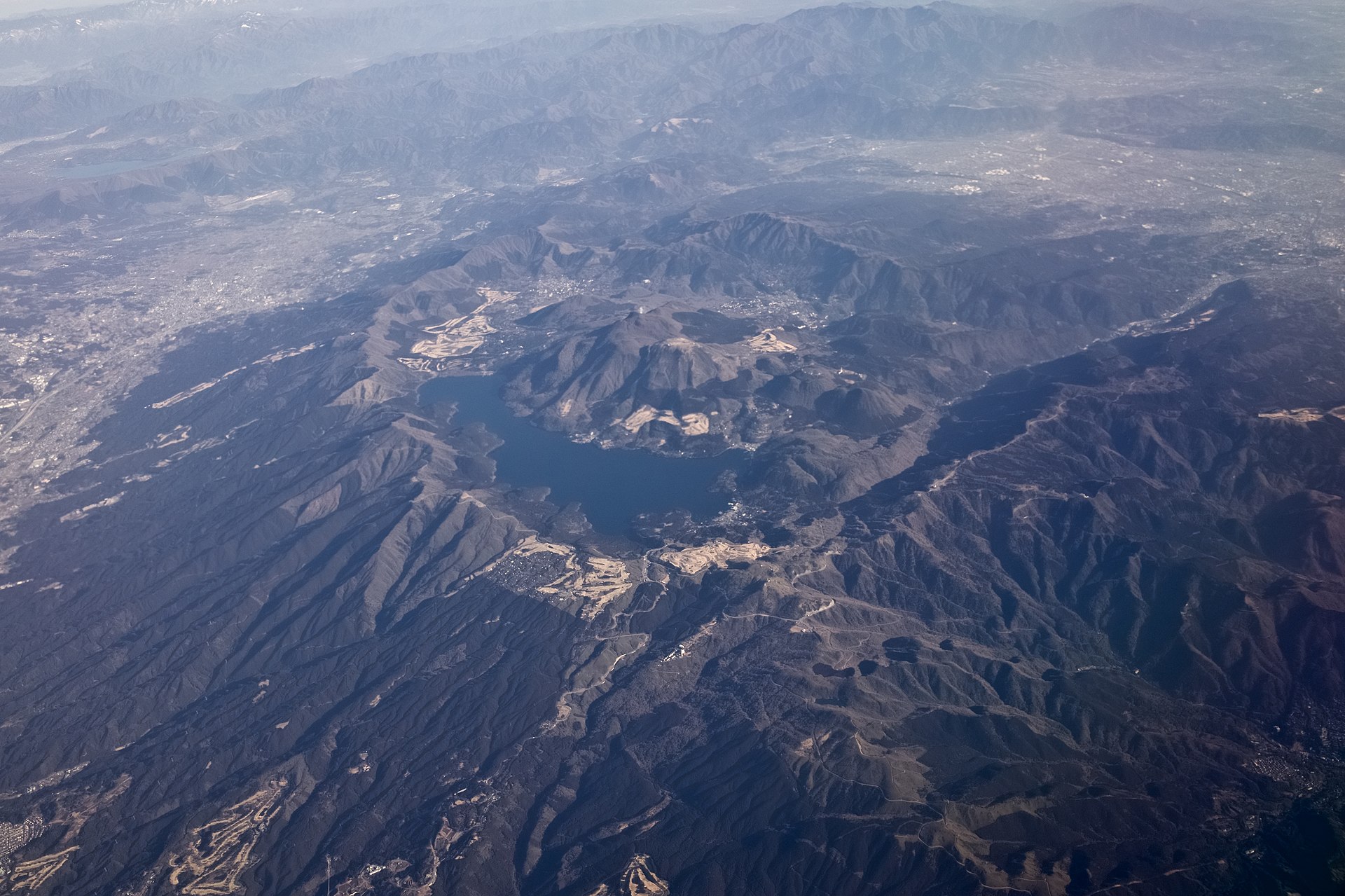
The eruption tore off the top of the mountain creating the geography seen today. Mt. Hakone is an active caldera that is still pumping out gases and volcanic material slowly rebuilding the volcano. Aerial photographs provide a better perspective of how this was once a massive volcano with Mt. Myojingatake pictured in the upper center as one of the side walls of the once massive volcano:
After taking in the view I continued to follow the trail towards the summit of Mt. Myojingatake:

Along the way I spotted this very larger rock memorial which I have no idea what it represented:

The next landmark I passed during my hike was the trail intersection to Daiyuzan Saijyouji Temple. The trailhead at the temple is a popular location to hike up Myojingatake from its eastern slopes:

Just passed the temple intersection I had my first unobscured view of Mt. Fuji rising in the distance in front of me:

Down below me I had a great view of the Gora neighborhood on the slopes of Mt. Hakone:

Looking behind me I could see the sunrising over the Pacific Ocean with the city of Odawara visible down below:

I next came to a trail marker that said I was only 5 minutes from the summit of Mt. Myojingatake:

I soon arrived to the summit of the 1,169 foot Mt. Myojingatake:

Here is the view of Mt. Fuji from the summit:

The pointy mountain in the foreground is Mt. Kintoki which surprisingly is higher in elevation than Mt. Myojingatake even though from the summit it looks smaller:

The mountain is famous in Japan as being the birthplace of a legendary folk hero named Kintaro. On the summit there was a signboard that explained a bit of the history of Kintaro:

Even further out in the distance passed Mt. Fuji I could see the snow covered Japanese Alps:

Here is the view looking back towards Mt. Hakone:

From Mt. Myojingatake I could see the gas from Mt. Hakone’s caldera pumping out into the air. From the village of Gora there is a popular cable car that goes directly over the caldera to a point near the top of Mt. Hakone:

Here is a panorama of the view from the summit:

After spending about 30 minutes at the summit I decided to retrace my steps back down the mountain. On the way back I spotted pyramid shaped Mt. Oyama rising up among the Tanzawa Mountains near Tokyo:

The descent down the mountain was super quick since the sun was now up and it was downhill the entire way. In less than an hour I found myself back at the trailhead:
I then walked down through the neighborhood to get back to my hotel to complete my hike;

Conclusion
.
Share this:

About The Author
Dobbs
I am a avid hiker with a love for travel and the outdoors. I currently call the Evergreen State of Washington my home.
