
Hikes in Japan: The Gotemba Trail
Summary
The Gotemba Trail is the longest and most difficult of the four trails up Mt. Fuji. That is why only 10% of hikers each year summit Mt. Fuji using this trail. The lower number hikers means this is the only trailhead hikers can drive their own vehicles too, the rest of the trailheads require hikers to take a bus. For anyone looking to do this hike in one day I recommend a very early start since it took me a little over 12 hours to complete. Most people will probably need to complete this hike in two days by staying in one of the handful of mountain huts below the summit. However, you do this hike I highly recommend it. It may be long and hard, but there are few people on the Gotemba Trail and the descent down the Osunabashiri is unlike anything I have ever experienced. This is a tiring, but incredible hike!
Have you hiked the Gotemba Trail before? If so let everyone know what you thought of it by clicking a star below!
Basic Information
- Name: Gotemba Trail
- Where: Mt. Fuji, Japan
- Distance: 12 miles (20 km)
- Maximum Elevation: 12,389 feet (3,776 m)
- Elevation Gain: 10,194 feet (3,107 m)
- Time: 12-16 hours
- Difficulty: Hard
- More Information: Official Mt. Fuji website

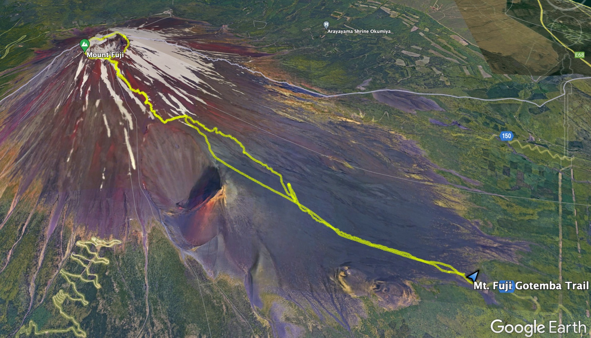
Google Earth Map of the Trail
Directions
Parking
The Gotemba Trail is the only trailhead of the four main trail up Mt. Fuji where people can park their privately owned vehicles at. The other trailheads all require shuttle buses to reach them. Due to the difficulty of the Gotemba Trail it sees far fewer hikers than the other trailheads. There is multiple large parking lots located just below the Gotemba Trailhead. I hiked this trail on a weekend during the main hiking season and still had no problem finding parking. Many people actually camp out in their cars and get up early to do the hike from this trailhead.
Narrative
I have attempted to hike Mt. Fuji twice in the past and was deterred each time by bad weather the day I planned to hike. This year while in Japan the day I planned to hike Mt. Fuji weather was finally not going to be a problem; I just needed to decide which trail I was going to take up the mountain. I decided to push myself and take the Gotemba Trail which is considered the most difficult trail due to its length and elevation gain. This trail only sees about 10% of the hikers that make the climb up Mt. Fuji each year. So after taking a short nap I then made the drive over to the Gotemba Trailhead:

After parking I then walked up to the trailhead known as the new 5th Station just above the parking lots. The new 5th Station has restrooms, a bus station, and a small shop known as the 1/2 Mountain Store:

The trailhead for the Gotemba Trail is marked by this large wooden tori gate:

I started my hike at 01:30 AM in the morning in an attempt to see the famed sunrise from near the top of Mt. Fuji. It was very dark out and I thus turned on my red lens head lamp and followed the signs pointing me towards the summit of Mt. Fuji:

Compared to staying in the Tokyo area the blackness of the night was quite noticeable. I could even make out the constellation of Orion the Hunter even though it was right above the glow of the city below the mountain:

Looking up at Mt. Fuji I could also see many stars as well as the lights of the hikers making their way up the trail ahead of me. I could also see the brighter lights of the mountain huts just below Mt. Fuji’s summit where hikers can rent a cot for the night before hiking up to the summit to see the sunrise:

Here is the sign I passed stating that I was entering Fuji-Hakone-Izu National Park:

In the darkness I then passed the Oishi-Chaya Teahouse which was closed since it was so early. This place would be quite busy when I passed by later in the day. After the teahouse it was just a trudge through the darkness up the mountain. For the first half of the hike the trail is composed of volcanic ash. When the trail gets steep it creates a two steps forward and a half step sliding back type of effect. However, I just kept putting one foot in front of the other and pushed forward. Besides darkness and ash I did eventually run into this closed down inn halfway up the mountain. The sign said it was closed due to COVID-19 and would reopen next year:

Next to the inn I spotted this tracked vehicle which is used by the businesses on the mountain to move goods up the mountain. These tracked vehicles have their own special trail they use that hikers are supposed to stay off of:

From the inn I continue to trudge my way up the mountain. About three quarters of the way up the mountain I had a really beautiful view of the city lights below Mt. Fuji and the approaching sunrise:

As I hiked higher up the mountain the sun continued to rise and the views became even more beautiful:


As I hiked even higher I passed by Mt. Hoei which is a crater from Mt. Fuji’s last eruption between 1707-1708:

I next reached what was called the 6th Station, but there was nothing there but a clearing for what was likely an old inn:

This is the spot I decided to stop and take in the views of the approaching sunrise:


After watching a spectacular sunrise I then restarted my hike up towards the summit of Mt. Fuji:

I soon came to a trail intersection where hikers can access the descent trail called the Osunabashiri or hike over to the Mt. Hoei Crater:

I continued my hike on the ascent trail and eventually I began to see less ash and more rocks the higher up I got:

Here is a picture of one of the larger rock formations the trail went passed:

Up ahead of me I could see another teahouse coming into view:

Like the lower teahouse this one was closed up as well due to COVID:

I did have a nice view of the sunrise from the teahouse:


As I ascended higher up the mountain I saw a lot more of these green bushes on the ground:

Here is a close up look at what one of these plants looks like:

I next hit the 3,000 meter mark which let me know I was about 1,000 more feet from reaching the summit which seemed so close:

Just above the 3,000 foot sign I reached a teahouse that was open and serving breakfast. I thought about stopping to eat, but decided against it because I felt I was in a good hiking rhythm and making excellent time up the mountain:

This teahouse is known as the 7.4 station and is 2.5 kilometers away from the summit:

Just above the teahouse I came to the 7.5 station where the lodging for hikers was actually open. The lodging is very basic with the operators giving hikers a sleeping bag and foam pad to sleep on:

Here is another view of the sunrise from this teahouse:

As I ascended further up the trail I came to the final teahouse located on the Gotemba Trail:

This teahouse also had lodging along with food service:

The sign pictured below gives an idea of how much food costs this high up the mountain. For example coffee was about $5.00 a cup, udon & ramen were about $8.00, and curry was about $13.00:

At this teahouse I could see the operators unloading goods and loading garbage on to the tracked vehicle that travels all the way up this mountain. The cost of fuel for the tracked vehicle has to be expensive and thus why food costs are so high:

From this final teahouse there was a sign that said I was 90 minutes from the summit which meant at my current pace I would probably make it in about an hour:

I found that passed the final teahouse the trail definitely became even steeper, which caused me to pause to catch my breath more before pushing on:

However, every time I stopped I was rewarded with sweeping views:

I next passed by this prominent rock formation that featured a striking red streak of lava rock:

This was a sign of things to come because the upper reaches of Mt. Fuji are covered in lava rock to include the 8th station literally being covered in lava rock:

The 8th station is largely a destroyed shelter that is 1.2 kilometers from the summit. I did find a number of worn out hikers taking a break here though:

The 8th station is a nice place to take a break with its expansive view:

From the 8th station the summit crater felt so close because I could see it just above me:

However, the trail was composed of steep, narrow, and rocky switchbacks that caused people to pile up into a conga line:

I was getting backed up behind slower groups of people and it was difficult to pass because of how narrow and rocky the trail was:

I decided to stop along this section and take a good 10 minute rest to allow the conga line of hikers ahead of me to push forward because I was tired of following them at such a slow speed. During my little break I just enjoyed taking in the views of the clouds that had quickly rolled in from the nearby ocean:

After my short break I then made the final push to the summit where I saw the tori gate marking the end of the Gotemba Trail just ahead of me:

On the summit there was a madhouse of people which was very different from what I experienced on the hike up the Gotemba Trail where few people were seen:

With all the people from the four different trails that lead up Mt. Fuji ending in the same place, it created an almost party like atmosphere on the summit with so many people excited to finally get to the top. The end of the Gotemba Trail had this little shrine that some people were giving prayers at before taking congratulatory selfies at the end of the trail:

Many of them were taking selfies with the view of the Mt. Fuji summit crater behind them:

From the end of the trail I pushed on to the true summit of Mt. Fuji called Kengamine Peak. To get there I followed the crater trail that went under yet another tori gate:

Here is the view from the tori gate looking down on the end of the Gotemba Trail which a number of storage buildings are also located:

Just below Kengamine Peak there is a Shinto temple:

The temple was closed due to COVID, but there were still many people walking up and giving short prayers in front of the temple:

Near the temple is a great view of Mt. Fuji’s summit crater. The crater was much larger than I was expecting:

Ahead of me I could see the true summit of Mt. Fuji, Kengamine Peak:

As I began my final push to Mt. Fuji’s summit I was hit with a strong wind and could see swirling clouds and the ocean in the distance below me:

The final ascent trail to Kengamine Peak was very steep and slippery. The fact that I was above 12,500 feet also made breathing a little bit more difficult as well:

I actually found myself holding the fence poles to help me up the mountain because of how slippery the trail was. However, I successfully made it to the summit of the peak that is capped with a weather and research station:

People were lining up to take a picture with the official summit marker at 12,388 feet or 3,776 meters:

Here is the view from the summit looking towards the crater:

From the summit I decided I had enough energy to do a complete circumnavigation around the crater. As I walked around the crater I was getting pummeled by a cold howling wind. I just sucked it up and trudged on forward enjoying the views. For example in the distance I could see the central Japanese Alps which seemed tiny compared to Mt. Fuji:

Something I did not realize until I hiked around the summit crater is that Mt. Fuji has two summit craters. The summit crater trail passes right between the main large crater and the smaller crater pictured below:

Here is a view of the main crater viewed from the smaller crater with Kengamine Peak visible in the background:

Below is a picture of a tori gate on the edge of the main crater with Kengamine Peak in the background:

Along the side of the crater there is also just a random marker showing a 3D model of Mt. Fuji:

As I reached the opposite side of the crater from the Gotemba Trail I entered a small neighborhood where the main Yoshida Trail ends. Here all the shops were open and selling their goods to the large number of people on the summit. This shop is where I bought me a Mt. Fuji hiking stick and was able to get brands burned on it at the stations on the way down:

On this side of the summit there was a Shinto temple that was open that people were giving prayers at:

After spending a little bit of time at the Yoshida Trail village I then continued my hike around the summit crater:

Here is a look at the summit crater from the opposite side of Kengamine Peak:

I soon found myself back at the marker that designates the end of the Gotemba Trail:

From the top of the trail I could see that a thick layer of clouds had rolled in below Mt. Fuji. I was hoping that I would not get rained on:

After spending over an hour on the summit I then began my descent down the Gotemba Trail:

With how steep the trail was I had to be careful descending on the slippery lava rock, but I made great time and was soon below the area with the teahouses:

I next came to the intersection for the descent trail:
The descent trail is called the Osunabashiri which in Japanese stands for the Great Sand Run:

This trail is unlike anything I have ever experienced before on a mountain. The steepness of the slope and the softness of the ash on the trail makes for perfect running conditions. I was moving fast down Mt. Fuji now even when I entered a thick cloud covering with a little rain falling on me:

The only thing that slowed me down towards the end of the Osunabashiri was when a blister on my big toe popped. The constant decline was causing my toes to be smashed into the front of my hiking boot. Finally a blister formed a burst. It hurt more when I ran compared to walking so I walked the rest of the way back to the trailhead. Walking did give me more time to appreciate these strange looking flowers that cover the lower slopes of Mt. Fuji:

I was amazed how quickly I had gotten back to the teahouse near the trailhead. It was open now and I stopped and bought some snacks and had the final brand burned into my hiking stick:

From the teahouse I then followed the trail into the tree line and back to the parking area:

Back in the tree line I could see signs that I could not see earlier in the morning due to the darkness such as this one declaring Mt. Fuji a World Heritage Area:

Back at the 5th station trailhead there is a large map of the area as well:

At the trailhead the 1/2 Mountain store was open as well:

As I walked back towards the lower parking lot, I passed by the bus station for the Gotemba Trail:

By the time I got back to van, my roundtrip hike up the Gotemba Trail took a little over 12 hours. It took my just under 7 hours to reach the crater summit, a little over two hours circumnavigating the summit and taking pictures, and about 3 hours to descend. The time though is not the most difficult part of this hike, it is the elevation gain. My GPS finished with over 10,000 feet of elevation gain. This is the most I have ever completed before in one hike. Most trail guides say to not do this trail in one day, but I proved if you are fit it is definitely doable. For most people though staying overnight at a hut is probably advisable.
Conclusion
The Gotemba Trail is the longest and most difficult of the four trails up Mt. Fuji. That is why only 10% of hikers each year summit Mt. Fuji using this trail. The lower number hikers means this is the only trailhead hikers can drive their own vehicles too, the rest of the trailheads require hikers to take a bus. For anyone looking to do this hike in one day I recommend a very early start since it took me a little over 12 hours to complete. Most people will probably need to complete this hike in two days by staying in one of the handful of mountain huts below the summit. However, you do this hike I highly recommend it. It may be long and hard, but there are few people on the Gotemba Trail and the descent down the Osunabashiri is unlike anything I have ever experienced. This is a tiring, but incredible hike!
Share this:

About The Author
Dobbs
I am a avid hiker with a love for travel and the outdoors. I currently call the Evergreen State of Washington my home.

Thanks for the info! I took this trail down on the second day of the hike. It was long 🙂 The trail length info is surprisingly hard to come by, when I try to figure out how much I walked back to the new 5th station. Your article says 12 miles — is that one way or round trip (I think it is round trip)?
@Charlene, my GPS measured my hike at 12 miles and that includes doing the loop completely around the crater. It would probably be a couple of miles shorter if not doing the crater loop.