
Hikes in Japan: The Mt. Kusato Trail (草戸山)
Summary
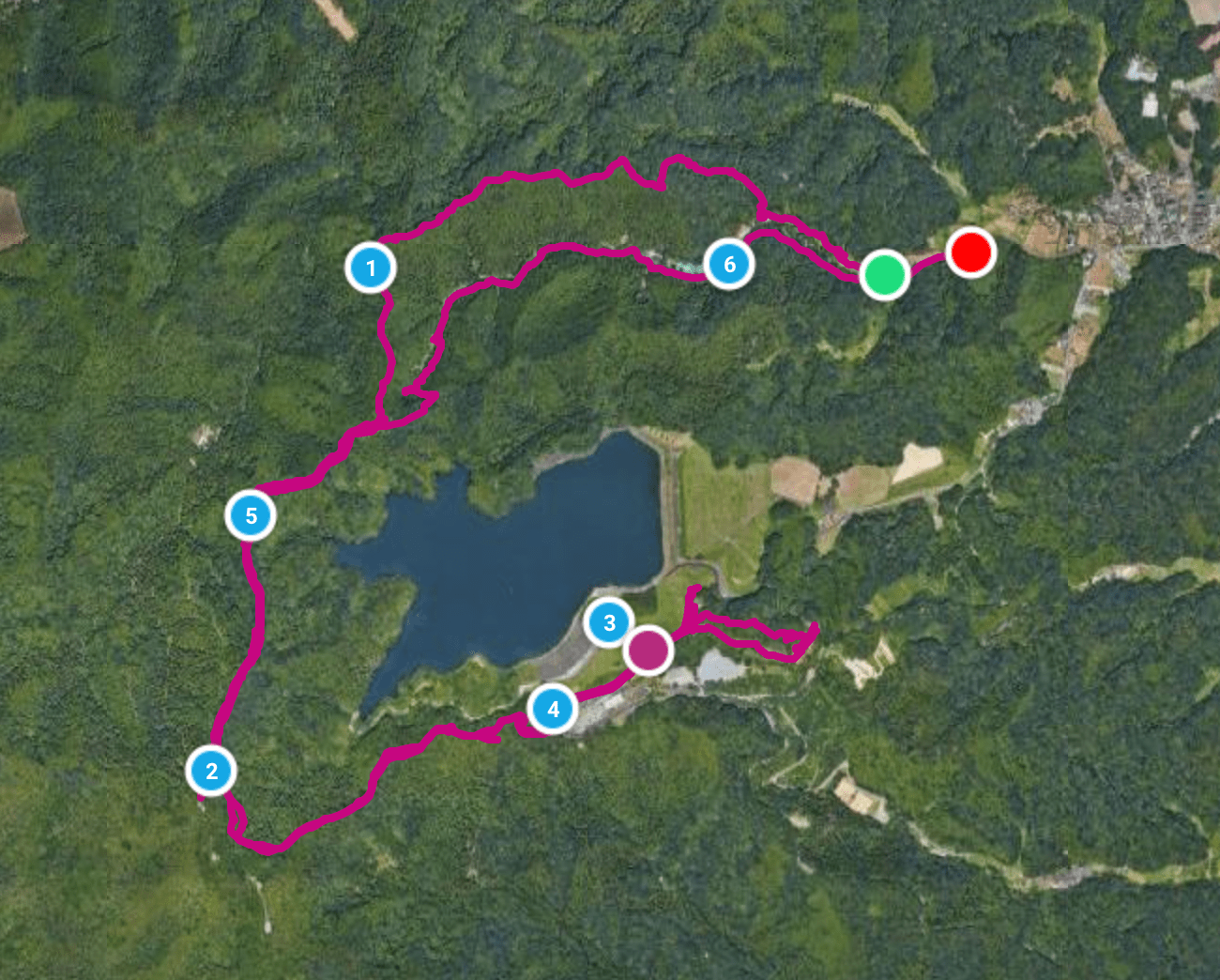
Overall the hike to Mt. Kusato is pretty easy and friendly for most families with young kids. It is about 2 miles roundtrip to complete. For those looking for a greater challenge the walk over to Lake Shirogawa greatly extends the length of the hike to 6 miles. For those looking for even more of a challenge this area has a variety of trails that extend off in other directions.
Have you hike up Mt. Kusato? If so let other know what you thought of the hike by clicking a star below!
Basic Information
- Name: Mt. Kusato Trail (草戸山)
- Where: Machida, Japan
- Distance: 6 miles
- Maximum Elevation: 1,194 feet (364 meters)
- Elevation Gain: 1,649 feet
- Time: 3-4 hours
- Difficulty: Moderate
- More Information: Tokyo Walking Map
Google Earth Map of the Trail
Directions
The trailhead for Mount Kusato is located at the Ochizawa Youth Center northwest of Tokyo. There is no nearby train station so the trailhead is best reached by vehicle.
Parking
Just below the Ochizawa Youth Center there is a large parking lot. When I arrived at 6:30 in the morning there was plenty of parking, however when I returned at about 10:00 the lot was nearly full.

Narrative
The Tokyo area can seem overwhelmingly urban, but fortunately there are hikes that can be found about hour outside of the city. One of those hikes is Mt. Kusato. This mountain is more of a high hill, but when combined with hiking up other hills on the ridgeline it makes for a decent hike that is 6 miles long with over 1,500 feet of elevation gain. From the trailhead parking lot, the hike begins by following the paved road towards the Ochigawa Youth Center:

If anyone was thinking of running into the forest and shooting the first deer you see, think again. There is a big sign at the trailhead prohibiting rifle hunting in the forest:

After a short distance of walking up the road I spotted this cartoonish map of the hike to Mt. Kusato. To help determine where to go on these Japanese maps and signs just look for the Kanji characters of 草戸山 that stand for Mt. Kusato:

From the sign I spotted this boardwalk path that followed adjacent to the road:

The boardwalk eventually led to a bridge that crossed over a small creek:

On the other side of the creek the Ochigawa Youth Center had an obstacle course set up for their campers to use:

Near one of the obstacles I noticed another trail sign that depicted the route to Mount Kusato:

From the map sign I followed a path into the thick forest:

Now that I was hiking in the thick forest it was like a signal to every mosquito to begin attacking me. Fortunately I had long pants on so I just had to fight off the mosquitos from my arms and neck. I forgot to pack mosquito spray and I am not making that mistake again:

As I hiked up the trail I made sure to follow the signs marked with the below Kanji which means “Kusato Pass”:

Along the path there are other trails that lead in other directions so it is important to follow the correct trail Kanji to stay on the right course. When I reached Kusato Pass it was simply a clearing with a few simple benches:

From Kusato Pass I followed the signs for Mt. Kusato (草戸山):

From the pass I had plenty of more up hill hiking to do:

I then came to a trail intersection that featured the first sign with English subtitles:

This intersection also had a nice view of the surrounding hills filled with primarily cedar trees:

From the intersection the trail followed a ridgeline that led to Mt. Kusato:

Once the ridgeline reached Mount Kusato I had to do a steep hike up to its summit:

Getting to the summit of the 364 meter, Mt. Kusato ended up taking me less than a hour to do:

The first thing I saw on the summit with this Shinto shrine:

There is also a large gazebo on the summit to escape the sunshine from:

The summit also had multiple maps to help orient hikers to the area:

From looking at one of the maps it appeared I could hike to Mt. Enokubo and then around Lake Shiroyama before heading back to the youth center to make this a loop hike:

So I decided to make this a loop hike head over to the lake. Before heading out I made sure to get a few pictures of the view looking out towards the Tokyo suburb of Machida:

Here is a closer look at the city:

After spending about 20 minutes on the summit I began to traverse down the ridgeline that runs between Mount Kusato and Mount Enokubo:

As I hiked across the ridgeline I came to another gazebo:

From the gazebo there was a nice view of Lake Shiroyama:

A short distance passed the gazebo I came to a trail fork. I took a right here to hike a short distance to the summit of Mt. Enokubo:

From the summit of Mt. Enokubo there are no views and just a bench. From the summit the trail does continue deeper into the mountains to Misawa Pass:

I turned around from the summit and returned to the trail fork. At the fork I now took a left. The wide trail quickly began descending down the mountain:

I next spotted this marker that led to a side trail:

The side trail led to this large stone marker which I have no idea what it means:

As I returned down the side trail back to the main trail I made sure appreciate the only flowers I saw during the entire hike:

After the short walk back up the side trail, I returned to the main trail and continued my descent:

The main trail ended at a paved road that twisted around a power substation:

I followed the paved road up towards Lake Shiroyama:

The paved road ends at a large parking lot that has a great view of the lake:


Here is a view of the Honzawa Dam that formed the lake:

Here is a panorama of the lake:

This large sign explained how the lake is used to generate electricity:

After taking in the views I walked over to another large trail sign. The sign showed that the remain route around the lake was closed across the dam. This meant I was going to have to retrace my steps to get back to the trailhead:

I decided before turning around to go ahead and hike over to nearby Mt. Tatsugo to see a Buddhist temple located there:

Along the way I took some more pictures of Lake Shiroyama:


After a short distance I found myself at the small Buddhist temple:

Adjacent to the temple was the locked gate that prevented hikers from walking around the lake back to the youth center:

Since I could not continue the hike around the lake I decided to spend some time checking out the Buddhist temple which was deserted:

From the temple there was nice view of the nearby hills:

From the temple I then hiked up to the summit of Mt. Tatsugo:

Along the way there is a signboard explaining the view:

The view was pretty spectacular and way out in the distance I could actually see the skyscrapers of central Tokyo:

After the viewpoint I next came upon a small Buddhist shrine:

Finally the top of the mountain was capped with this small Buddhist marker:

From the Mt. Tatsugo I then retraced my steps back to Mt. Kusato which meant a lot more stair climbing:

Once I found myself back on the summit of Mt. Kusato I then followed a trail that quickly descended back to the youth camp:

I next found myself at a small dam at the bottom of the valley where a creek flowed:

After a short distance the trail turned into a dirt road that led to the youth center:

The dirt road passed through an area of some really nice cabins that the kids were staying in:

This large map I passed shows how big the Ochigawa Youth Center is:

I then walked passed a large building that appeared to the administrative center of the youth camp. I short distance passed this building I found myself back at the trailhead parking lot to conclude my hike:

Conclusion
Overall the hike to Mt. Kusato is pretty easy and friendly for most families with young kids. It is about 2 miles roundtrip to complete. For those looking for a greater challenge the walk over to Lake Shirogawa greatly extends the length of the hike to 6 miles. For those looking for even more of a challenge this area has a variety of trails that extend off in other directions. I will likely be back in the future to explore more of these trails.
Share this:

About The Author
Dobbs
I am a avid hiker with a love for travel and the outdoors. I currently call the Evergreen State of Washington my home.
