
Hikes in Washington: The Sentinel Trail at Fort Spokane
Summary
Overall our walk around Fort Spokane was 1.5 miles long and took about an hour to complete since we stopped to read each signboard. Since there was not a whole lot of buildings or views to see, my kids lost interest in this hike pretty quickly. The beating sun did not help as well. For an adult like myself I found Fort Spokane to be pretty interesting and provided a nice glimpse into what life was like for a soldier stationed on the American frontier.
User Review
( votes)BASIC INFORMATION
- Name: The Sentinel Trail
- Where: Fort Spokane Visitor Center & Museum
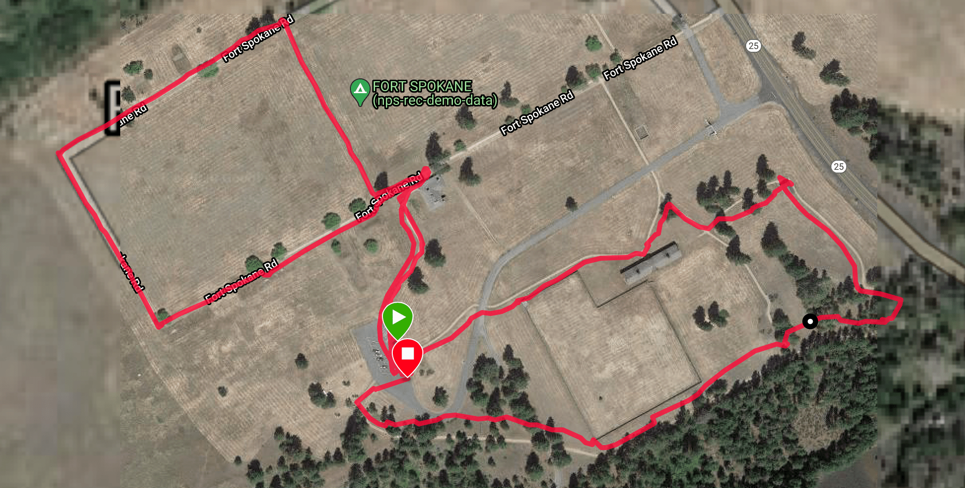
- Distance: 1.5 miles
- Elevation Gain: 43 feet
- Maximum Elevation: 1,464 feet
- Time: 1 hour
- Difficulty: Easy
- More Information: Day Hike! Spokane, Coeur d’Alene, and Sandpoint

Google Earth Map
Directions
To get to Ft. Spokane take Highway 2 west from Spokane for about 35 miles to the small farm town of Davenport. In Davenport make a right on to Highway 25 that travels north to Ft. Spokane. It should take about 30 minutes from Davenport to reach Ft. Spokane.
Parking
At Ft. Spokane there is a very large parking lot that will have plenty of space available for all vehicles types even on a busy weekend. Just drive through the large entrance gate to access the parking lot. There is no fee to park at Ft. Spokane.
Narrative
Looking for an easy day trip for my kids, I decided to take them on a drive to the mouth of the Spokane River where it empties into the Columbia River. It is at this river intersection that the historic Fort Spokane is located at. The fort is part of the Lake Roosevelt National Recreation Area that was formed by the damming of the Columbia River that created a large lake. Since the fort is part of a National Recreation Area it is preserved by the National Park Service. As we approached Fort Spokane there was a bluff I was able to pull over at and see the river intersection ahead of me. Below me I could see the open grassy field where Fort Spokane is located at:

Here is wider angle picture of the view from the bluff:

Before driving into Fort Spokane we decided to drive across the Spokane River and stop at a viewpoint to get a good look at the strategic location the fort was built at:

Back during the late 1880’s, both the Spokane and Columbia Rivers would not be as large as they were today due to the damming of the river. There were both the two main waterways in Eastern Washington that the native people and settlers would have used for travel. Above the intersection of the two rivers we could see the bluff that Fort Spokane was strategically located at to monitor traffic on the two rivers:

Here is a wider angle photo of the river intersection:

After checking out the views we then drove over to Fort Spokane. At the parking lot there is a information board that provides a brief history about the fort:

The fort was built in 1880 interestingly not to fight the native people in the area, but instead to protect them. The Spokane Reservation was established on the north side of the Spokane River and soldiers at Fort Spokane were tasked with patrolling the river to keep settlers out of the lands of the Spokane people. The fort only lasted until 1898 when its soldiers were recalled to fight in the Spanish-American War.

The following year the buildings on the fort were converted into a boarding school for Native-American children. The school closed in 1929 leaving the fort to go into disrepair. Over the years locals scrapped the buildings and reused the wood. One of the few structures left at Fort Spokane is the below pictured brick building known as the Guardhouse. The Guardhouse is where all the weapons at Fort Spokane would have been securely stored at:

Today the Guardhouse is used as a visitor center, but due to the COVID-19 restrictions it was closed by the National Park Service. As my kids and I approached the Guardhouse we passed by the fort’s flagpole:

Near the flagpole there is a sign that shows the hike around Fort Spokane that is known as the Sentinel Trail. The trail received its name because this was the route that a soldier would of tooken around the fort when on guard duty:

Near the visitor center there was also another signboard explaining the history of Fort Spokane and a historic picture of what the fort looked like during the 1800’s:

Our walk around the Sentinel Trail began at the expansive parade field:

After every location along the Sentinel Trail there was a signboard to explain what we were looking at:

We then walked around to the opposite side of the parade field looking back at the old guardhouse:

The opposite side of the parade field was known as Officer’s Row because this is where the officer housing was located. Today all that is left of the officers’ housing is the foundation:

Here is a signboard that depicts the officer housing:

The largest foundation that remained was from the Bachelor Officers Quarters:

This signboard shows how big this building once was:

We next followed the trail back to the other side of the parade field backdropped by a large lava rock bluff:

There other side of the parade field is where the barracks and housing for enlisted servicemembers were located at:

From here we followed the trail back to the parking lot and followed the road over to the corral. This is where the soldiers at Fort Spokane would have kept all their horses at, which were a necessity for patrolling the frontier:

During the winter time it would have been important to keep the horses in the extremely large Cavalry Stable located adjacent to the corral to keep them warm from the elements:

Here is the signboard that explains more about the stable:

The stable is in great shape and it is surprising that this wooden structure survived being torn down after all of these decades:

Near the corral is where the Powder Magazine is located. Due to it being a brick building it survived from being torn down. This building is where the soldiers would have kept all of their gunpowder for their rifles and cannons. The magazine was constructed far from any of the homes and barracks in case of an accidental explosion:

From the Powder Magazine the trail heads over into the tree line adjacent to the bluff:

Back here is where the soldiers had a saw mill located at to process wood they would have needed for building materials:

This signboard shows what the saw mill looked like back in the late 1800’s:

From the saw mill the trail heads back to the parking lot by looping behind the corral:

There is actually an option to hike up the Bluff Trail to see views of Fort Spokane from the cliff line. However, my kids were not up to because it was blistering hot walking around the fort. There is no shade during this hike and they were eager to get back to my truck and turn on the air conditioning. For anyone taking the Bluff Trail it will add another half mile to the hike:

Conclusion
Overall our walk around Fort Spokane was 1.5 miles long and took about an hour to complete since we stopped to read each signboard. Since there was not a whole lot of buildings or views to see, my kids lost interest in this hike pretty quickly. The beating sun did not help as well. For an adult like myself I found Fort Spokane to be pretty interesting and provided a nice glimpse into what life was like for a soldier stationed on the American frontier.
Share this:

About The Author
Dobbs
I am a avid hiker with a love for travel and the outdoors. I currently call the Evergreen State of Washington my home.

Mr. Dobbs: Thank you for an excellent photo tour of the Ft. Spokane grounds! I will be taking my history-buff oldest grandson there in a few weeks and your tour makes me look forward to it even more. I also discovered in my local library system an excellent history of the fort published in 1988 entitled “Sentinel of Silence” by David H. Chance. Well worth the read! Thanks, again!
@Chuck, I hope you and your grandson have a great visit to Ft. Spokane. For anyone that likes local Spokane history this is a location well worth checking out. Thanks for the book recommendation!