
The Columbia Plateau Trail: The Sterling Road Trailhead
Summary
The Columbia Plateau Trail is a real gem of the Washington State Parks system due to its easy accessibility and great scenery. Despite its accessibility, outside of the Fish Lake portion of the trail, it does not see much traffic, especially the Sterling Road Trailhead. This is not an official trailhead which means even less foot traffic at the section of the trail. The wide trail makes this a great hike for young kids. My 7 year old completed the 4.5 mile hike with no issues. The trail is also popular for trail running as well. I highly recommend getting out and exploring this great trail.
User Review
( votes)BASIC INFORMATION
- Name: Columbia Plateau Trail (Sterling Road Trailhead)
- Where: Cheney, WA
- Distance: 4.5 miles
- Maximum Elevation: 2,358 feet
- Elevation Gain: 92 feet
- Time: 2 hours
- Difficulty: Easy
- More Information: Washington State Parks website
")
MAP OF THE TRAIL
")
DIRECTIONS
This hike is located just outside of the small town of Cheney. To reach the trailhead from Spokane, take I-90 West about 15 miles and then exit onto Highway 904 to Cheney. Stay on the highway and drive through downtown Cheney. On the outskirts of Cheney take a left on to Mullinix Road. Follow this road for about 12 miles and then make a left on to Sterling Road. For this dirt road for about a mile where the trailhead is located.
Parking can be found only on the side of the dirt road. After parking look for the below trail barriers that designate the start point of this hike:
")
NARRATIVE
With the coronavirus continuing to lock down things around the state, one of the few things that the public can still do is go hiking as long as social distancing is practiced. Wanting to avoid crowds my seven-year old son and I decided to hike the section of the Columbia Plateau Trail that runs from Sterling Road to the Turnbull National Wildlife Refuge. We had previously hiked from the Amber Lake Trailhead to Sterling Road and now wanted to hike further down the trail. The Columbia Plateau Trail is one of the very popular “Rails-to-Trails” projects in the Pacific Northwest, which means it is wide and well maintained:
")
The Columbia Plateau Trail is built on the old Spokane, Portland and Seattle Railroad trackbed that was constructed in 1908. The line was eventually taken over by the Burlington Northern Railroad who discontinued using the track in 1987. This opened the door for the state of Washington to take over the property which they did in 1992. Since then the Washington State Park Service has continued to develop the 130 mile trail that runs from the Tri-Cities area to Fish Lake.
")
From the Sterling Road Trailhead the hike follows the old Milwaukee Road railway bed as it runs adjacent to one of the many wetland ponds in the area:
")
Some of the old railway mileage markers can be seen posted along the route:
")
Besides the ponds and forests that can be seen, another common site along the Columbia Plateau Trail is basalt rock.
")
This basalt rock is left over from the intermittent lava flows that once covered Eastern Washington beginning 17 million years ago. The intermittent lava flows stopped about 6 million years ago and the hotspot that produced the flows is currently located at Yellowstone National Park. It may be hard to believe but the basalt that covers Eastern Washington is about one mile thick.
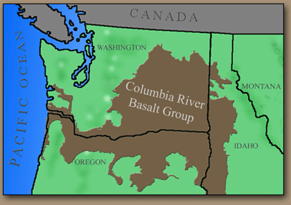
Later the basalt along almost the entire length of the Columbia Plateau Trail was carved out by a series of Ice Age floods that occurred 28,000 to 13,000 years ago when an ice dam in Idaho thawed and released flood waters from the enormous Lake Missoula across Eastern Washington creating the terrain today known as the Channeled Scablands:

The most interesting portion of the hike is when we hiked through a narrow man-made gorge:
")
On the left side of the gorge we could see how the railway workers long ago had dug out this gorge and then piled up the rocks there:
")
This drone footage I took gives a better look at the gorge and the old piles of rock above it that was dug out:
")
The gorge is not the only old sign of the railway, along the route old railroad ties can be regularly spotted as well:
")
After passing through the gorge the trail comes to the largest pond along this section of the Columbia Plateau Trail:
")
We next came to the first of two gates that designates the entrance into the Turnbull National Wildlife Refuge:
")
The second gate has a sign next to it that explains the mileage to the Cheney Trailhead as being 6.25 miles away for those who want to through hike passed here:
")
My son and I were happy with reaching the wildlife refuge gate and then proceeded to take a break and eat some snacks for lunch. I then broke about my drone to take some more pictures of the area. Here is a picture looking northeast that shows the trail passing through the Turnbull Wildlife Refuge:
")
Here is the same view from even higher up in altitude:
")
Click the below photo to view a drone video I shot going northeast up the trail:

To the northeast I could see the snowcapped, 5,209 foot Mica Peak:
")
Here is the view looking towards the southwest showing the trail we already hiked across from Sterling Road:
Here is the same view from a little higher up in altitude:
")
Click the photo below to watch a drone video I took going southwest down the trail:

Here is the view looking towards the southeast where way out in the distance Steptoe Butte could be seen:
")
Looking to the east I could see more ponds that litter this section of the Channeled Scablands as well as the mountains of Idaho in the far distance:
")
To the west there was just more trees before giving away to the wheat fields of Eastern Washington:
")
After spending about 30 minutes playing around with the drone my son and I then began I return hike back down the trail to the Sterling Road Trailhead:
")
We make quick time going back and ran into the only people we saw all day which was a total of three people. So we succeeded very well at social distancing for the day.
")
Conclusion
My son and I had a great day out and away from the house with this 4.5 mile hike. The Sterling Lake Trailhead is one of the least hiked portions of the trail so if you want to avoid crowds this is the place to do it. The nice wide trail also is great for families with young children. My 7-year old son had no issues with this trail. For those looking for a longer hike this section of the hike can be combined with the Amber Lake section to create a 10 mile round-trip hike. However, you decide to explore the Columbia Plateau Trail it is well worth getting out and doing so.
Share this:

About The Author
Dobbs
I am a avid hiker with a love for travel and the outdoors. I currently call the Evergreen State of Washington my home.
