
On Walkabout On: The Mt. Bierstadt Trail, Colorado
Basic Information
- Name: Mt. Bierstadt Trail
- Max Elevation: 14,065
- Where: Guanella Pass, Colorado
- Distance: 11 miles
- Time: 6-8 hours
- Elevation Gain: 2,838 feet
- Difficulty: Medium-Hard
- More Information: 14ers.com
Route Up The Mountain

GPS Map of the Trail

Note: This map was made using the MapMyFitness App for the iPhone. For whatever reason the app stopped the elevation gain at 13,999 feet. The actual summit of Mt. Bierstadt is 14,065 feet.
Narrative
I have been training the past few weekends at Mueller State Park in preparation for trying my first winter ascent of a fourteen thousand foot mountain here in Colorado.
- On Walkabout On: Mueller State Park’s Outlook Ridge Trail
At the park I had been practicing using my snowshoes and trekking poles as well as developing my endurance to walk in the snow in preparation for climbing one of Colorado’s 54, fourteen thousand foot mountains this winter. Over the recent Martin Luther King Jr. Holiday weekend I decided to try and climb the 14,065 foot Mt. Bierstadt which is located in the Front Range to the west of Denver:
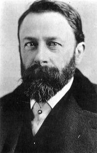
Mt. Bierdstadt is considered one of Colorado’s most accessible and easiest fourteeners to climb since it does not require technical climbing skills. This mountain’s popularity seems to have carried over to its naming because it is named after Albert Bierstadt who was a popular painter of Colorado’s mountains and other natural features in the Old West back in the 1800’s. He is also credited with being the first person to climb this mountain along with nearby Mt. Evans:
Here is an example of one of his pieces of art:

After seeing the beautiful Mt. Bierstadt myself it seems this mountain was a perfect one to name after someone who painted such dramatic landscape portraits.
To reach the mountain I traveled to Denver from Colorado Springs and then took I-70 west towards Georgetown, Colorado. I expected the drive to take me about 2 hours and 15 minutes to get to the trailhead, but something I forgot to anticipate was all the skiers traveling to the mountains for the long weekend. So it ended up taking me an extra hour to get to Georgetown because of the unbelievable early morning traffic on I-70. When I reached Georgetown I was quite happy to exit the slow moving highway. Georgetown is actually a pretty cool little town due to its historic buildings that have been beautifully restored throughout the town:

This is one of those towns I am going to have to take some time and thoroughly visit this summer. The town even has its own steam engine train that takes visitors on a tour of the area. I will definitely have to come back here and check it out sometime. From Georgetown I had to find Guanella Pass Road to take me to the trailhead. The road ended up being quite easy to find since Georgetown has signs directing people to the road throughout the town. Guanella Pass Road from Georgetown winds steeply up the surrounding mountains to where it eventually provides a dramatic overlook of the historic town:

I was expecting to find a lot of snow on the road, but the Colorado Department of Transportation has really done an excellent job keeping the road clear of ice and snow:

It helps that there had not been a major snow storm in over a week, but regardless I was impressed how well maintained the road was, so thank you CDOT for maintaining this road so well. Something else I was impressed by was that this steep mountain road that travels up to a maximum altitude of 11,669 feet (3,557 meters) is completely paved:

It is rare to find a road like this in Colorado that is completely paved. This gives some indication of how popular this road is during the summer time for people day tripping from the Denver area. Another likely reason it is paved is also because of the Cabin Creek Hydroelectric Project located in the valley:

Despite being paved the whole way, the Colorado Department of Transportation only plows the road up to the Guanella Pass Campground during the winter and springs months. At the campground there is a large parking lot where everyone has to park their vehicles at before beginning their venture into the mountains:

From the parking lot I took a look at the road ahead that leads to the summit of Guanella Pass. The snow appeared to be quite thick:

Not knowing what to expect on the route ahead I decided to put on my shoeshoes for the walk up the road. From the parking lot I had to walk up Guanella Pass Road an additional two miles to reach the summit of the pass where the trailhead for the Mt. Bierstadt trail is located at:

I began my hike at 0830 in the morning which was an hour later than I planned to start due to the traffic I encountered on I-70. I found that for the most part the road can be hiked without snowshoes because previous hikers have packed the snow enough to where it was fairly easy to walk on. In some areas people did fall through and struggle through some deep snow, but for the most part I found that snowshoes were not needed on the road:

As I walked up the road I found the views of the surrounding mountains to be truly breathtaking:

The most breathtaking view of all though is seeing the famed “Sawtooth” that runs between Mt. Bierstadt pictured on the right and Mt. Evans on the left side of the photo:

After 2 miles and 45 minutes of walking I reached the summit of Guanella Pass:

On the summit of the pass there are no trees and thus no shade on the road. This allowed the snow on the paved road to actually melt at the summit:

From the top of Guanella Pass I had some great unobscured views of the surrounding mountains:

The summit of Guanella Pass is where the summer time trail to Mt. Bierstadt begins. At the trailhead there is a large parking lot and a restroom to support the thousands of hikers that come up here during the summer months:

This trailhead is located at 11,674 feet which means the hike from here to the summit of Mt. Bierstadt is a 2,391 foot climb. However, during the winter the hike from the Guanellas Pass Campground adds an additional 2 miles and 447 feet of altitude gain. From the trailhead here is how the hike begins, by walking through some deep snow:

Just over this large snow drift there is a sign that has a nice map of the Mt. Evans Wilderness that Mt. Bierstadt is part of:

From the sign the path leading to Mt. Bierstadt drops down a hill for about a mile to cross through the infamous willows:

During the summer this area is a large high altitude marsh that required hikers for many years to wade through its swampy waters to get to the mountain. However, in recent years a boardwalk has been installed that has allowed hikers to walk over the willows:

Since the temperature was in the upper twenties Fahrenheit everything was frozen over and some people just wore snowshoes and crossed the willows that way instead of using the boardwalk:

There is still one part of the willows however that did not have a boardwalk, but was frozen solid and thus easy to cross:

After crossing the willows the steep ascent up the slopes of Mt. Bierstadt begins:

There is a trail left by hikers who have packed the snow very well. So for the ascent I did not need snowshoes, but this is something that can change depending on the conditions. I did wear my microtraction crampons over my hiking boots which I found to be very useful and recommend to anyone hiking up Mt. Bierstadt in the winter.
As I gained altitude up the mountain I was soon rewarded with a nice view looking down over the willows:

Here is the view looking towards the northwest where down in the tree line is where the Guanella Pass Campground is located at that I began my hike up Mt. Bierstadt from:

I had read in my guidebook that Mt. Bierstadt had a large herd of mountain goats that lives on it. I was hoping to see them during my climb up the mountain, but unfortunately the only sign I saw of these goats was the droppings they had left on the side of the mountain:

Definitely the most impressive thing I saw when climbing up Bierstadt was the rugged “Sawtooth” that runs between Bierstadt and Mt. Evans:

Climbing across the Sawtooth from Mt. Bierstadt to Mt. Evans is actually a popular thing for climbers to do, but for me it was just to dangerous and I was not going to try it. I was more than happy just to admire the Sawtooth from below.
Eventually the trail ends its switchback up the mountain and eventually enters an area of increased steepness and rock:

From here it is just a tough climb up the rocks to a saddle on the mountain where a large cairn is located:

From the saddle I had my first views looking towards the east and south which provided me a distant view of the isolated fellow 14er Pikes Peak:

Here was the view from the saddle looking to the west where I spotted Grays and Torreys Peaks rising like a pair of dog ears out in the distance:

Here is a closer look at these two stunning 14ers with Grays Peak on the left and Torreys Peak on the right:

A few months ago I actually tried to climb Grays and Torreys Peaks and got turned around due to the poor weather that hit me as I try to ascend up the summit ridgeline towards Grays Peak. The wind was so bad I felt like I was going to get blown off the mountain so I turned around. Seeing these mountains again even from afar motivates me to go and try and climb them again later this year. However, first I still had to negotiate my climb up Mt. Bierstadt. From the saddle I had the option of climbing up this huge ice sheet towards the summit:

I decided to not climb the ice sheet because of the fear of creating an avalanche and tumbling off the mountain. So I went around the ice to the west side of the mountain’s rock face and ascended up that way. This required some rock scrambling which at such a high altitude was a bit tiring. There was even patches of snow in between rocks that I stepped on that I sunk up to my waist in. So began to use my trekking poles to really hit the snow hard to make sure I don’t sink into it before stepping on it. This is the part of the hike that I saw other hikers turn around at and go back down due to the difficulty.
Here is a view as I ascended up the final summit dome looking down on the summit ridgeline towards the saddle below:

It took me about 30 minutes from the saddle to reach the 14,065 foot summit of Mt. Bierstadt:

Here is the official marker from the US Geological Survey confirming the summit of Mt. Bierstadt:

Also at the summit the Colorado Mountain Club was nice enough to leave a register for climbers to sign in at to confirm that they complete the hike up Mt. Bierstadt:

It was very cold on the summit but fortunately the wind was just a breeze which made it bearable. I hung around on top of the mountain for about 20 minutes enjoying the view and taking pictures. To northeast of Bierstadt the view is dominated by the massive Mt. Evans which is connected to Mt. Bierstadt by the Sawtooth:

The 14,265 foot Mt. Evans just like Pikes Peak even has a highway that runs up to near the top of the mountain which I could just barely make out. I haven’t been up on Mt. Evans yet, but I definitely plan in the future to both hike and drive up the mountain.
Here is the view looking east where the foothills of the Front Range were visible as well as even the Great Plains way out in the distance:

Of course rising to the southeast was the great Pikes Peak in all its glory:

The view from Mt. Bierstadt really shows how unusual Pikes Peak is because of its isolation compared to Colorado’s other major mountains that all below to a range. Pikes Peak just rises up above 14 thousand feet from the prairie all by itself. Really the only mountains in the Rockies that compare to Pikes Peak are the Spanish Peaks further south that also rise dramatically out of the prairie.
Below is a view from Mt. Bierstadt looking directly south which shows the large inland basin of South Park:

This large basin is what separates Pikes Peak from the rest of the great mountains of the Colorado Rockies. Here is the view looking southwest towards all those other great peaks of Colorado’s Rocky Mountains:

Here is the view looking west where once again Grays and Torreys Peaks dominate the view:

Here is a closer look once again at this beautiful peaks:

After spending 20 minutes enjoying the view I began to get really cold, especially my feet due to the inactivity on the summit. As much as I would have liked to have spent more time on the summit my body was telling me it was time to go. So I left the summit and began working my way back down through the rocks:

Once I got out of the rocks the descent down the mountain became much quicker:


In less than an hour of descending down the mountain I found my self back crossing through the frozen willows again:


From the willows the next mile of the hike up to the summer trailhead is all up hill but it wasn’t very steep and easy to hike up. After about 30 minutes I was back at the summer trailhead talking to other hikers who had also hiked Bierstadt that day:

Not everyone made it to the top though because some people got sick from the altitude, but everyone did have a great time regardless. After spending about 15 minutes talking with other hikers at the summer trailhead I then proceeded to hike the two miles back down Guanella Pass Road to the winter trailhead:

Soon enough I was back at the parking lot watching the sun set on yet another great day in Colorado’s mountains:

Conclusion
Mt. Bierstadt for good reason is a very popular destination for weekend hikers from the Denver area. The mountain is easy to access and not an extremely difficult 14er to hike up. This means that the summer time crowds can be quite large on the mountain. That was the main reason I decided to hike up this mountain in the winter because I knew the crowds would not be there. I would estimate that on the holiday weekend that I hiked up Mt. Bierstadt that there was only about 20 other people on the mountain that day. It was enough people to where I did not feel alone on the mountain, but it was also a small enough number where I did not feel crowded either. This hike made me very happy that I decided to take up snowshoeing and explore Colorado’s mountains during the winter months. Hiking in the winter takes some more preparation than hiking in the summer, but I am so far finding it to be very enjoyable and can’t wait to try hiking up yet another 14 thousand foot mountain.
Share this:

About The Author
Dobbs
I am a avid hiker with a love for travel and the outdoors. I currently call the Evergreen State of Washington my home.
