
On Walkabout On: Mt. Rosa, Colorado During the Winter
Basic Information:
- What: Mt. Rosa
- Where: Colorado Springs
- Elevation: 11,499 feet
- Distance: 14.5 miles round-trip
- Elevation Gain: 4,337 feet
- Difficulty:
Easy–Medium– Hard –Difficult - More Information: SummitPost.org
Route Up Mt. Rosa

Topographic Map of the Mt. Rosa Trail

Elevation Map of the Mt. Rosa Trail

Narrative
One of the most prominent peaks in the Colorado Springs area is the pointy summit of the 11,499 foot Mt. Rosa that rises above the city to the Southwest. Here is a picture of Mt. Rosa taken from the Templeton Trail at Palmer Park which also shows the approximate route I took up the mountain:

Maybe it is because of how famous Pikes Peak is that Mt. Rosa does not see many hikers, but it is really a great climb that I recommend to anyone looking for a challenging hike with great views of the Colorado Springs region. There are a couple of ways to hike up Mt. Rosa with the longest and most challenging route accessed from North Cheyenne Canon Park:
The dirt parking lot above Helen Hunt Falls known as the “Hub” serves as the trailhead for this hike. Since it was dark out when we started our hike here is a picture of the “Hub” from later in the day:

From the “Hub” the hike up to Mt. Rosa is 14.5 miles long and features 4,337 feet of ascent. This is a longer hike with more ascent than many 14ers. I met up with a co-worker I recruited to come with me and we set off up the trail at 06:30 in the morning. Our goal was to get up to the summit before 11:00 when strong winds were forecasted to hit Colorado Springs followed by a minor winter storm. It was still dark out when we began our hike and we covered the first couple of miles on the Gold Camp Road section of the hike to the top of the collapsed railway tunnel pretty quickly. Here is a picture of the tunnel from a previous hike:

Gold Camp Road used to be the rail line for the Colorado Springs and Cripple Creek District Railway that began operations in 1901. The railway was one of many competing railroads transporting supplies and people to the gold mining boom towns of Cripple Creek and Victor and bringing ore back down the mountain to be processed in mills in Colorado City near present day Colorado Springs. The middle section of the road became a hiking and biking only section due to the tunnel collapse. Here is the view of the sunrise over Colorado Springs from the top of the collapsed tunnel:

From there we took a right onto Trail 624 towards St. Marys Falls. There is a big sign showing the way to St. Marys Falls and Mt. Rosa. Here is a picture of the sign once again from a previous hike:

I have hiked up this trail many times and never get tired of the beautiful little valley between the railway tunnel and St. Marys Falls. Here is a picture of the first rays of sun beginning to enter into the valley:

Due to the amount of trees in the valley the trail was covered in ice which forced us to use microspikes for traction. It took us about 30 minutes of hiking up the valley before we reached the base of Stove Mountain:

From there the trail began to switchback up a hill towards St. Marys Falls. Due to the weather concerns, my buddy and I decided to bypass taking the short trail to St. Marys Falls in order to take advantage of the continuing good weather and continue hiking up towards Mt. Rosa. There is a sign at the St. Marys Falls trail intersection that list Mt. Rosa as 3 miles away, but this is inaccurate:

Mt. Rosa is in fact is 4 miles away with about 3,000 more feet of elevation gain to contend with. It is still a long and difficult hike to Mt. Rosa from the falls; so do not be fooled by the sign. Once we ascended above St. Marys Falls the trail began to become increasingly covered with snow. We had brought our snowshoes with us, but the snow was solidly frozen and was not very deep. So we had no issues walking over the snow. Trail 624 ends at a dirt road called FS 381 that is very popular with motorbike riders during the warmer months. The forest service had to put up a fence though to keep them off of Trail 624:

So we passed through the fence and next had to find Trail 672 that would take us to Mt. Rosa. This is the tricky part of the hike because it is very easy just to pass through the fence and follow the road towards Mt. Rosa because it leads right to it:

This direct looking path down FS 381 to Mt. Rosa is in fact the wrong way. It seems just about everyone I know who hiked up Mt. Rosa for the first time has made this mistake. I know this because I made this mistake myself when I first hiked up Mt. Rosa two years ago. The mistake added about three miles to my hike before I realized I went to wrong way and backtracked. I was not about to make that mistake again. My buddy who was leading at this point started heading down the road towards Mt. Rosa and I told him that we needed to go away from the mountain. He gave me a funny look and I told him to trust me, you have to go away from the mountain to get up it. So we took a right and walked a short ways up the dirt road to find Trail 672. The marker for the trail is not obvious from the road, but there is a small pile of rocks letting people know to look for the trail to the left:

The Forest Service trail marker is not obvious, but it is there in the trees:

Trail 672 is where the hardest part of the hike begins. It is a steep and monotonous switchback up the side of Mt. Rosa’s far northern ridge. Additionally the snow on the mountain had become much deeper which forced us to stop and put on our snowshoes:

We could see that one other person had hiked up here in the past few days with that person’s tracks slightly visible which helped with route finding up the mountain:

Once we got on top of the ridgeline at about 11,000 feet in altitude there was no more trail to follow because the snow had covered up the footprints of the person who had been up here before us:

Additionally from this point snowshoes were a must because of how deep the snow was. So we just simply headed south towards the final summit approach to Mt. Rosa:

From the ridgeline to the West we also had our first views of the 12,367 foot Almagre Mountain and the 14,115 foot Pikes Peak:


Here is a closer look at the seldom seen south face of Pikes Peak:

You can read about my prior hikes up these two mountains at the below links:
As we worked our way up the mountain I also could see the 10,707 foot Cameron Cone rising up in the distance to the North:

You can read about my previous hike up Cameron Cone at the below link:
The last 500 feet up to the summit of Mt. Rosa was pretty tough because even with snowshoes we found ourselves sinking into deep snow in some areas:

We just kept cursing the deep snow and pushing on until we eventually topped out on the summit of Mt. Rosa. The summit is basically a pile of rocks surrounded by small trees that mostly do not obscure the view. This causes Mt. Rosa to have some of the best views in the region. Here is the view from the summit looking towards the seldom seen south face of Pikes Peak in the Northwest:

Here is a panorama photo from the summit of Mt. Rosa looking towards Pikes Peak:

To the Southwest I could see the 11,224 foot Mt. Big Chief in the foreground and the mighty Sangre De Cristo Range in the distance:

Here is a closer look at the Sangre de Cristos which had a storm brewing over them:

To the South we had an incredible view of the Penrose-Rosemont Reservoir that lies directly below Mt. Rosa:

To the Southeast I could see the great plains meeting the Rocky Mountains as well as the 12,347 foot Greenhorn Mountain in the distance:

You can read about my previous hike up Greenhorn Mountain at the below link:
To the East was a bird’s eye view of Cheyenne Mountain and Colorado Springs:


Finally here is a panorama photo of the view from the summit with Pikes Peak visible on the far right:

Something that is historically very cool about Mt. Rosa is that in November 1806, the explorer Captain Zebulon Pike led a small party of men that climbed up Mt. Rosa after an aborted attempt to try and climb Pikes Peak. Pike was trying to get a good viewpoint of the area and Mt. Rosa was going to have to do after their failed summit attempt of Pikes Peak. From the summit of Mt. Rosa he called the peak that would eventually be named after him “Grand Peak”. Pike and his men spent a frigid night surviving a snow storm below the summit of Mt. Rosa before reuniting with the rest of his men down below. So it is pretty cool to be taking in the same views that Pike did over 200 years ago.
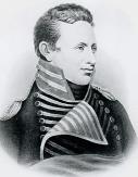
Zebulon Pike
Anyway unlike Pike who did not have the benefit of an established trail system it had took us 4 hours to summit Mt. Rosa which made the time now 10:30. We only stayed on the summit for about 15 minutes because we could feel the wind picking up and see the ominous clouds coming in from the direction of the Sangre de Cristos. Plus it was just darn cold up there because we were soaked in sweat from the snowshoeing and our bodies had cooled down quite a bit. We were eager to get moving just to get warmed up again. Going down the section that lead to the summit of Mt. Rosa was a bit better then going up, but we still fell through a few sections of deep snow. However, going down Mt. Rosa we left a really good trench which hopefully other hikers are able to take advantage of before it fills back in:

We were soon back on the exposed ridgeline and now getting hit by pretty good winds just like the weather forecast predicted. Once we started down the monotonous switchbacks we were shielded from the wind which was nice. Once we got back to the intersection with Trail 624 we packed our snowshoes and just used microspikes for the rest of the hike. On our way down from Mt. Rosa we made a stop over at St. Marys Falls which continues to be completely frozen over for the winter:

Here is the view from the falls looking back towards Colorado Springs:

Here is a closer look at Colorado Springs where the dominant building we could see from this vantage point was the famous Broadmoor Hotel:

From the falls it was a three mile hike back to the trailhead. By the time we reached Gold Camp Road it was now snowing:

Conclusion
The snow was actually kind of a pleasant way to end the hike especially since the wind was not blowing down into North Cheyenne Canon. So by the time we got back to the trailhead we had hiked 14.5 miles in exactly 8 hours including breaks. This was the first time I hiked up Mt. Rosa during the winter and it was definitely more challenging then hiking up it in the warmer months. However, don’t be fooled even without snow Mt. Rosa is a tough hike from North Cheyenne Canon due to the distance and elevation gain. This makes Mt. Rosa a great conditioning hike for those of us who like hiking 14ers. Additionally Mt. Rosa is just a great hike for those looking for great views, solitude, and having a chance to walk in the footsteps of American history. If Mt. Rosa was good enough for Zebulon Pike to hike up over 200 years ago, it is good enough for people today to come check out as well.
Share this:

About The Author
Dobbs
I am a avid hiker with a love for travel and the outdoors. I currently call the Evergreen State of Washington my home.
