
On Walkabout On: Almagre Mountain Via Frosty Park – Part 2
Previous Posting: Almagre Mountain Via Frosty Park – Part 1
___________________________________________________________________________
From the basin where Stratton Reservoir is located at in the center of Almagre Mountain I headed up to the south summit of the mountain often called Baldy Peak. The south summit is capped by a radio tower that can actually be seen from Colorado Springs if one looks closely enough at the mountain. There is a road that was covered in snow that I followed that led to the radio tower:

From the road I had some really good views looking back towards Stratton Reservoir with the ridgeline that leads to the northern most summit of Almagre visible in the background:

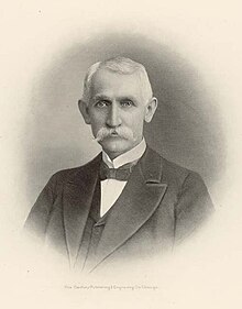
Stratton Reservoir is named after a very prominent Colorado Springs historical figure Winfield Scott Stratton. In 1891 Stratton discovered the Independence Lode near Victor, Colorado that became one of the richest gold mines ever discovered. By 1894 he became Cripple Creek’s first millionaire. Stratton though like other notable Colorado Springs tycoons was also an active philanthropist. He was inducted into the Mining Hall of Fame in 1990 and here is his profile on their website:
W.S. Stratton was indeed the “Midas of the Rockies.” For 19 years he was a failed prospector, but in 1891, his luck changed and he became legend. As owner of the Independence and Little Portland Mines, he was in control of the greatest gold producers in the history of Cripple Creek. Together, the two mines produced over $88 million of ore!
Arriving in Colorado Springs in 1868, he was following rumors of fortune to be had in the Pike’s Peak country. He continued to follow every rumor of gold in Colorado for the next 17 years with no success. Finally, he took a course in mineralogy and, armed with new knowledge, headed for Cripple Creek where, on July 4, 1891, he staked his claims on Battle Mountain. He hit the mother lode in his “dream mine,” The Independence, a rich vein of gold that never ran out! He then invested in what would become Cripple Creek’s greatest producer of all; the Little Portland Mine.
To “Crazy Bob” Womack, discoverer but not heir to Cripple Creek riches, Stratton wrote a check for $5,000 as consolation. When Cripple Creek burned to the ground leaving its population homeless, he insisted all emergency costs be charged to him. His anonymous gifts to the community were numerous and generous, and each Christmas he had coal delivered to the poor families of the mining towns. Most memorable of needy visitors to his door was H.A.W. Tabor, Leadville’s mining king. He was a beaten man, whose fortune had collapsed with the end of silver coinage. Stratton gave him $15,000 and saw to it he was named Postmaster of Denver; and when the famous Brown Palace Hotel was at the brink of bankruptcy, Stratton rescued it by paying off all of its bills. A gift of $25,000 to the Colorado School of Mines provided for completion of a “Hall of Metallurgy” which bears his name. In 1899, a deal involving the sale of stock on his mines gained him $10 million in cash, the largest mining transaction the world had seen! He set out to revitalize Colorado Springs, providing for parks, city hall, the county courthouse, the post office, and much more. When W.S. Stratton died in 1902, much of his estate served to establish a model home for the indigent near the posh Broadmoor Hotel. [National Mining Hall of Fame]
Due to generous legacy Stratton now has many things in Colorado Springs named after him to include the reservoir on top of Almagre Mountian. Here is a panorama image I took from the road with the southern summit on the left and the northern summit on the right with Stratton Reservoir right below it:

As I ascended up the road I also began to get my first views of the southern face of Pikes Peak:

I also had some nice views looking back towards Colorado Springs:

I could even make out the parking lot in North Cheyenne Canyon that I have often used for various hikes in the area which is also where a hike up to Almagre Mountain can also begin:

Something that was really annoying though about walking up the road was the weird angle I often had to walk at because of how the snow covered the road:

This was actually pretty painful for my feet after awhile. It took me about 30 minutes, but eventually I reached the summit of Baldy Peak:

The radio tower looks quite small from way down below, but once I was right next to it I could see that it was in fact quite large:

I had heard before that this was the highest microwave tower in the United States, but searching on the Internet I could find nothing official to prove this claim. If anyone knows please leave a comment. I had also heard that the building up here at one time was left open for hikers to use and even had a kitchen, but vandals had forced the building to be locked up:

Something the south summit did have for hikers was tremendous views of the seldom seen south face of Pikes Peak:

Pikes Peak definitely looks different from this vantage point. From this perspective the mountain looks more round compared to the views of its often seen eastern and northern faces which are extremely rugged. The elevation on Baldy is supposed to 12,226 feet, but according to my watch it was 12,239:

So my Garmin Fenix watch appears to be a little bit off, but overall considering it is a GPS watch I thought the accuracy was pretty good.
Below is a view of the true summit of Almagre Mountain which I would be heading to next:

Down below to the northwest I could also see frozen over Mason Reservoir that is also part of the lake system that provides water for Colorado Springs:

Looking to the northwest I could see where the mountain top that had been cleared where the gold mine at Cripple Creek operates:

Here is a closer look at the gold mine:

Off in the far distance to the west I could also see the Sawatch Range where many of Colorado’s highest mountains are located:

Down below I could also see Skagway Reservoir outside of Cripple Creek that is a popular fishing location:

To the northwest I could see more of the Sawatch Range:

Here is a closer look at these mountains:

From seeing some of the highest peaks in Colorado to my west, to the east was a different story where the Great Plains that run right up to the Front Range can be seen:

Looking to the east I could also see Cheyenne Mountain which is famous for being the location for NORAD:

Looking to the south I could see the 12,347 foot Greenhorn Mountain and making an appearance right behind Greenhorn was the 13,626 foot West Spanish Peak:

Here is a closer look:

I have previously hiked up both of these mountains and the postings I wrote for each of them can be viewed at the below links:
Looking towards the southwest the mighty Sangre de Cristo Range was visible:

You can view more pictures of the Sangres at the below posting:
I spent about 30 minutes on the summit of Baldy and then proceeded to walk down the road. On the way down instead of completely following the road I decided to snowshoe cross country off of the road back to the reservoir:

I figured since I hauled my snowshoes all the way up here I might as well use them. Going cross country definitely save me some time and I was quickly back at the reservoir. From there I walked across the aging dam that forms the reservoir:

Here is the view looking straight down into North Cheyenne Canyon from the dam:

On the other side of the dam I could not find a road to follow because everything was covered in a thick layer of snow:

So I just proceeded to go cross country again and climbed upwards to the summit:

By this time I was quite tired due to the distance I had already covered and the altitude was starting to get me a bit. I kept at it though and soon gained the ridgeline. From there I had an awesome view looking back towards the basin with the radio towers in the distance:

As I followed the ridgeline I eventually saw the true summit of the mountain ahead of me and it had little snow on it:

I made the short walk over to the summit and my watch said it was 12,263 feet high:

However, according to my map the summit is in fact 12,367 feet high. So I found out that my Garmin watch can be off up to about 100 feet in altitude which isn’t a big deal, but could be for people who want very precise GPS coordinates. For what I use it for it is good enough for me.
Anyway from the summit here is the view looking towards Pikes Peak again:

Here is the view looking back towards the radio towers:

Here was the view looking towards Colorado Springs:

Towards the northeast I had a bird’s eye view of the Waldo Canyon Fire area that scorched the southern most section of the Rampart Range that runs between Colorado Springs and Denver:

Here is a closer look at the burn scar:

Here is a closer look at the 10,707 foot Cameron Cone which is another local hike I want to complete sometime as well:

From Colorado Springs Cameron Cone looks quite big and imposing, but from up here it looks tiny. Here is a closer look at the mountain:

From the summit I walked down to the end of the ridgeline so I could get a view of Lake Moraine down below which is also another local hike I still need to complete:

Just like the other lakes I could see from the summit, Lake Moraine is also part of the Colorado Springs water supply system. Here is the view of Pikes Peak from the end of the ridgeline:

From the end of the ridgeline the terrain drops off steeply from Almagre down into the valley that Lake Moraine is located and then up the south slope of Pikes Peak. Here is the view looking towards the west where Pikes Peak has its own impressive ridgeline of mountains that extends out from it:

I spent about 30 minutes up on the summit of Almagre enjoying the views before I decided to begin heading back down. As I started to walk back across the ridgeline back towards the basin the wind began to pick up quite a bit which made me glad that I was getting off the mountain now:

It was definitely much easier going down the snow covered face of the mountain than it was going up it:

Soon I was back at the locked gate and enjoying views of the impressive rock formations in the upper reaches of North Cheyenne Canyon:

From the gate I then proceeded back down the rugged four wheel drive road which was like entering a whole different world from the snow and ice covered one I had just left on the top of the mountain:

As I walked down the road I could hear some voices up and ahead and at first I thought it was some hikers coming up the road:

However, after a closer look I could see two Jeeps trying to turn around up ahead because of the difficult road conditions:

I was actually impressed that they made it up of the road as far as they did. They should have just walked up to the basin which would have been about a mile walk to enjoy the views there, but they instead drove back down the mountain. As I walked down the road I noticed that more boulders had rolled off of the road then what I remembered walking up the road:

Since the temperatures had rose over the course of the day more snow was melting and thus triggering more boulders to roll down the side of the mountain. I made sure to keep a good watch of the hill side to my right to make sure I do not get hit by one of these boulders. I did however made sure to sneak a peek to my left occasionally to enjoy the sweeping views:

Soon enough I was back in the treeline and away from the exposed road and its boulder danger:

Once in treeline I was make good time since it was all down hill and I had little snow to worry about. The melting snow did make things quite muddy in some spots, but not a big deal. I also had to get off the road quite a few times to make way for all the four wheel drive vehicles using the road now. When I walked up in the early morning I did not see anyone, now these back roads were filled with vehicles. Something else I noticed as I walked down the road was the continuous hum of a Chinook helicopter flying around:


I eventually got back to the clearing above Frosty Park and was able to appreciate how far I had walked by looking back at the road I had covered that leads up to Almagre Mountain:

From the clearing I walked back to down to Frosty Park:

At Frosty Park I could see that the Chinook was doing high altitude landing practice:

Due to Colorado’s altitude and geography nearby Ft. Carson is often used as a place for helicopter pilots to train before going to Afghanistan. Something else I noticed as I walked back towards the Penrose-Rosemont Reservoir where I had parked my truck, was the amount of gun fire. From Frosty Park all the way to the reservoir I could see people parked on the side of the road target shooting. This area appears to be a very popular spot for people to go shooting at. There was even an extremely loud explosion of a bomb going off that I heard So between noisy vehicles on the road, helicopters flying above me, gunfire, and bombs going off I felt like I was back in Afghanistan instead of in the Colorado Rockies.
Soon enough I found myself back at the intersection where I had begun the hike at:

Since it was a bit dark when I started the hike I took more notice of the 11,224 foot Mt. Big Chief that loomed above me:

From there I walked across Gold Camp Road and back to my truck:

Conclusion
In total the hike was approximately 17.5 miles and it took me 8.5 hours to complete. It was a long day of hiking, but the views from the top of Almagre Mountain made it worth the effort. The views were so good in fact that I definitely want to try and hike up Almagre again some time in the future, but from the North Cheyenne Canyon trailhead instead. Looking on my map it appears this would actually be a shorter hike, but with much more elevation gain compared to starting from Frosty Park. From the North Cheyenne Canyon trailhead I also do not have to worry about dodging vehicles, getting buzzed by helicopters, getting shot at, or loud explosions as well. However someone wants to access Almagre Mountain make sure to check it out sometime if you live in the Colorado Springs area. It really is a beautiful hike that accesses a place rarely visited by people in the area.
Share this:

About The Author
Dobbs
I am a avid hiker with a love for travel and the outdoors. I currently call the Evergreen State of Washington my home.

Nice to see you are one of the few that know Baldy is a sub-peak of the South peak of Almagre Mt. Nice pictures.
@Art, you are correct because I have met many people who thought Baldy was the actual summit of Almagre.