
On Walkabout In: Hobart, Tasmania
Prior Posting: Port Arthur, Tasmania Part 2
______________________________________________________________
After visiting the old penal colony of Port Arthur, my wife and I continued our tour around Tasmania by traveling to the island’s capitol city of Hobart. The city was founded in 1803 as a penal colony, which makes it Australia’s second oldest city behind only Sydney. Hobart is home to roughly 220,000 people who find themselves in a beautiful city located along where the Derwent River empties into a scenic bay and is back dropped by the 1,271 meter Mt. Wellington:

Like just about every city in Australia, Hobart has its very own ANZAC memorial, which was located right near downtown in a beautiful park that overlooks the harbor:

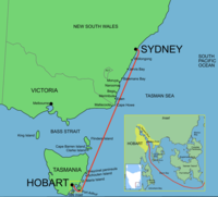
The most famous event that Hobart is known for around the world is the Sydney to Hobart Yacht Race, which occurs every December. This yacht race is a huge event in Australia and it is fun to watch the updates on the news on who is winning. When my wife and I traveled to Hobart we actually timed our visit to coincide with boats from the race arriving in the harbor:

This boat race is approximately 1,170 kilometers long and crosses the unpredictable waters of the Bass Strait between mainland Australian and Tasmania:
The most dangerous year for this boat race was in 1998 when five boats were sunk and six sailors died in the stormy waters of Bass Strait that year. This boat race, known as the Bluewater Classic in Australia, may be Hobart’s most famous event, but the most infamous moment in the history of the city may very well be when the Tasman Bridge that links Hobart with its eastern suburbs, collapsed killing 12 people in 1975:

The bridge now long repaired collapsed that year when a bulk ore barge hit one of the supports of the bridge. Not only did this accident lead to 12 deaths, but it also caused the eastern suburbs of Hobart that compose 30% of the city’s population, to be cut off from the rest of the city. The Tasman Bridge was the only traffic artery between the two sides of the city and the next bridge crossing to Hobart was a 90 minute drive. Needless to say the bridge collapse caused great social upheaval as people who lived on the east side could no go to the west side to work until ferry operations opened to move people across the bay. It took more than a year to get the bridge repaired, but since this tragedy more bridges have been constructed across the Derwent River to connect the two sides of the city.
This picture below from the slopes of Mt. Wellington shows how the city is cut in half by the Derwent River and the bay:

If you look closely, on the left side of the picture you can make out the Tasman Bridge crossing the Derwent River. Hobart I think is the most scenic looking location of any of Australia’s large cities, however my wife and I felt the best place to appreciate the city’s wonderful natural setting was from the top of Mt. Wellington.
Next Posting: The Summit of Mt. Wellington
Share this:

About The Author
Dobbs
I am a avid hiker with a love for travel and the outdoors. I currently call the Evergreen State of Washington my home.
