
On Walkabout At: Port Campbell National Park – Part 1
Basic Information
- What: Port Campbell National Park
- Where: Victoria Australia
- Founded: December 1964
- More Information: Parks Victoria website

Narrative
Australia’s Great Ocean Road has a number of fabulous sites to include pristine beaches, spectacular coastlines, beautiful waterfalls, ancient rain forests, giant trees, and attractive small towns. However, the most well known and most photographed area along Victoria’s Great Ocean Road is not any of these locations, but is in fact Port Campbell National Park. The park is located on the far end of the Great Ocean Road about 190 kilometers southwest of Melbourne:
The 12 Apostles is an area of limestone coastline that formed 20 million years ago that has been slowly eroded by the crashing ocean waves since that time. This erosion has resulted in a deeply fractured coastline that features a number of dramatic rock formations.
My wife and I had spent the night at a nearby campground in our trusty Coleman tent and woke up early in order to get to the park and see its most famous attraction the 12 Apostles before the crowds arrived. We were literally the first people at the park that morning and were greeted with off and on rain. It wasn’t enough rain to spoil our visit though.
The Gibson Steps
The first rock formation we stopped to see was at Gibson Beach:

The parking lot was on the cliffs high above the beach which could only be accessed by walking down what is known as the Gibson Steps:

These steps were carved by hand back in the 19th century and were quite slippery when I was walking down them because of the rain. Once on the beach we were rewarded with quite a dramatic view of the steep ocean cliffs:

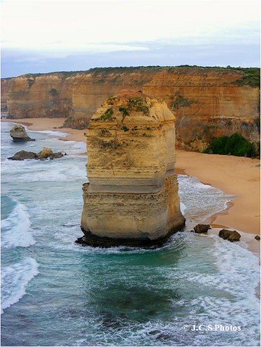
Besides having a great view of the cliffs, Gibson Beach also has a perfect view of the first of rock formation composing the 12 Apostles:

The 12 Apostles
From Gibson Beach my wife and I then made the short drive over to the next car park which is where the main visitor center for the park is located. It was still early and the visitor center closed, so we just followed the short trail to the viewing platform that overlooks the 12 Apostles:
No one is really sure who named the 12 Apostles because there is only seven of these fascinating rock formations now. The other five formations may have been knocked down by the crashing waves. In 2005 there was eight Apostles left until one suddenly collapsed due to the eroding waves. The rubble of that Apostle can be seen in the foreground of the picture above. Locals believe that there probably wasn’t ever 12 Apostles to begin with, but that a drunk with double vision incorrectly counted the number of rock columns and named the place. If you have been in Australia as long as I have, you would understand that this theory is totally plausible.
Anyway the individual rock formations are really stunning and the rock layers that composes them and the surrounding coastline can be easily seen:


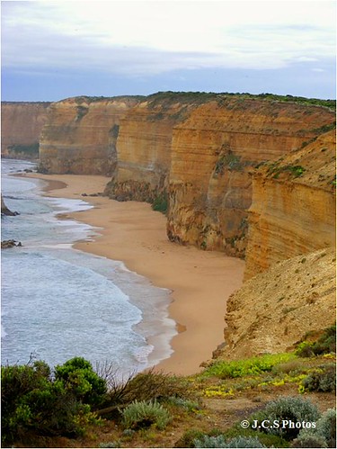
I also found myself fascinated by the steep coastline:

As can be seen by the erosion of the cliff face, the ocean’s water level once reached much high then is does today. With all the talk about climate change, it is very clear as can be seen here, that climate change has happened before and will happen again.
Anyway from the visitor center there is a variety of trails that run in each direction on top of the cliffs in order to get various views of the 12 Apostles and the dramatic coastal cliffs:

Following one of the trails heading off towards the east it lead out onto a peninsula that provided great views looking both towards the east and west. Toward the east I was able to get a view of the first rock columns I had saw over at Gibson Beach:


Looking west I had yet another view of the rest of the 12 Apostles:

Looking at the 12 Apostles it was interesting to see the how different each of the rock formations were. About half of them were really thick and bulky:

While the other half were slender and elegant:

The Shipwreck Coast
As stunning as this coastline is, it is important to remember that this area is known as the Shipwreck Coast because of the number of ships that have been lost on these rocky shores. In just one 40 year period 80 ships were lost along this coast due to the fog and hidden reefs that made navigation so treacherous in these waters.
By seeing these rocks, cliffs, and high waves for myself, it is easy to see why navigating these waters was so dangerous for early sailors. Unlike those early seafarers that crashed on these shores, I was safe on top of these steep cliffs taking in some great views. Despite the rain and wind I was getting battered with, I was having a great time and couldn’t wait to see the rest of this fantastic park.
Next Posting: Port Campbell National Park – Part 2
Share this:

About The Author
Dobbs
I am a avid hiker with a love for travel and the outdoors. I currently call the Evergreen State of Washington my home.

[…] This area has a variety of amazing rock formations that are distinctly different from the previous 12 Apostles to include this amazing arch known as the Island […]
please show the picture of previous ocean levels to the world,it may stop theiving poloticians using global warming as a scam to increase taxes!beautifull part of the world though,i wish to god i still lived there!
ezcellent articles though phil
Phil, thanks for visiting.
There is evidence of the former rise in ocean levels all across Australia to include the wetlands of Kakadu once being under the ocean. The Stirling Ranges out in Western Australia is another area where it is easy to see where the sea levels once were.
You are right though that Australia is a beautiful part of the world and I'm glad you are enjoying the site. Once again thanks for visiting.