
On Walkabout On: The High Point of the Grampians, Mt. Williams
Prior Posting: McKenzie Falls and the Jaws of Death
________________________________________________________
Next up during our camping trip to the Grampians National Park, was to walk up to the summit of the highest mountain in the range, Mt. William. Mt. William, named after the King of England at the time by Major Mitchell, towers 1167 meters above the rest of the Grampians. Reaching the mountain is only about a 30 minute drive south of Halls Gap. The drive south to the mountain is dominated by rocky peaks and scorched trees from the January 2006 bushfires that burned down over half the park:

Amazingly in such a short time the scorched bush has turned very green:

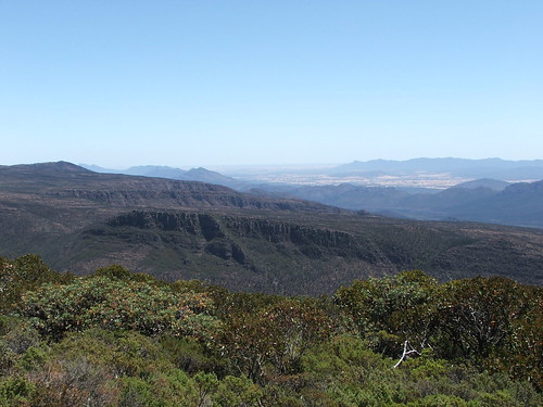
The trail to the summit of the mountain is easy to reach by just following the signs off the main highway to a road that winds steeply up the side of Mt. William and provides outstanding view looking towards the north of the park:


The road eventually stops at a parking lot where the path to the summit begins. The path is actually a road that is locked by a gate that provides access to a large radio tower on the summit of the mountain:

The road is very steep even though it is paved, so give yourself an hour to get up it if you are of moderate fitness. A short walk from the radio tower leads you to this monument commemorating the British explorer, Major Mitchell’s 1836 summiting of the mountain:


Here is the rock outcropping on the top of the mountain:

The views from the mountain’s summit are absolutely spectacular. Here is the view looking towards the east:

About 250 miles over the horizon in the above picture is where the state capital of Victoria, Melbourne is at. Here is the view looking towards the west:

This next picture is a view looking directly north:
If you look closely in the above picture; off in the distance the far northern peak is actually Mt. Stapylton that I had climbed earlier during my trip. Finally here is an iconic Grampians view looking towards the northwest:

Mt. Williams is an easy summit to access with great views thus making it a definite must see for anyone thinking about checking out the Grampians.
Next Posting: Exploring the Southern Grampians
Share this:
About The Author
Dobbs
I am a avid hiker with a love for travel and the outdoors. I currently call the Evergreen State of Washington my home.

[…] Prior Posting: The High Point of the Grampians, Mt. Williams […]